The global Remote Sensing Technology is witnessing remarkable growth as governments, research organizations, defense agencies, and commercial enterprises increasingly rely on geospatial intelligence for informed decision-making. Remote sensing technologies enable users to collect information about the Earth’s surface without physical contact through satellites, aircraft, drones, and advanced sensors.
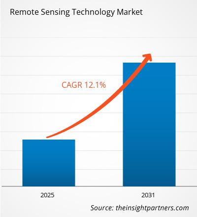
According to The Insight Partners, The Remote Sensing Technology Market size is expected to reach US$ 50.44 Billion by 2031. The market is anticipated to register a CAGR of 9.0% during 2025-2031.
Market Overview
The Remote sensing technology utilizes sensors mounted on satellites, drones, aircraft, and other aerial platforms to capture electromagnetic radiation reflected or emitted from the Earth’s surface. These data are processed to generate valuable insights regarding land use, vegetation, water resources, climate patterns, infrastructure, and environmental changes.
Modern remote sensing solutions combine optical imaging, radar systems, infrared sensors, hyperspectral imaging, and LiDAR technologies to deliver highly accurate geographical information. Industries increasingly depend on these technologies to improve operational efficiency, reduce costs, enhance environmental sustainability, and support strategic planning.
The growing availability of satellite constellations and cloud-based image processing platforms has significantly improved data accessibility, making remote sensing more affordable for commercial users.
Key Market Drivers
- Growing Adoption of Earth Observation Satellites:-Governments worldwide continue investing in Earth observation programs to strengthen national security, environmental monitoring, weather forecasting, and disaster response capabilities.
- Rising Demand for Precision Agriculture:-Agriculture represents one of the fastest-growing application areas for remote sensing technology. Farmers utilize satellite imagery, drone mapping, and multispectral imaging to monitor crop health, optimize irrigation, detect pest infestations, estimate yields, and improve resource utilization.
- Increasing Defense and Security Applications:-Defense organizations increasingly rely on remote sensing for border surveillance, intelligence gathering, military planning, and reconnaissance missions.
- Expansion of Cloud-Based Processing:- Traditional desktop-based geospatial analysis is gradually being replaced by cloud computing platforms.
- Cloud-based remote sensing solutions offer scalable processing capabilities, faster image analysis, easier collaboration, and lower infrastructure costs.
Emerging Market Trends
- Artificial Intelligence and Machine Learning Integration:-Artificial Intelligence and Machine Learning are revolutionizing remote sensing by automating image interpretation, object detection, land classification, and predictive analytics.
- Growth of LiDAR Technology:- Light Detection and Ranging (LiDAR) has become one of the most significant technological advancements in remote sensing.
- Rise of CubeSats:- CubeSats are transforming satellite-based remote sensing by reducing launch costs and increasing revisit frequency.
Get Sample PDF of the report @ https://www.theinsightpartners.com/sample/TIPRE00003307
Market Segmentation
By Type
- Passive Remote Sensing
- Active Remote Sensing
Passive systems rely on naturally available electromagnetic radiation such as sunlight, whereas active systems emit their own signals using radar or LiDAR technologies.
By System Type
- Visual Remote Sensing System
- Infrared Remote Sensing
- Optical Remote Sensing
- Microwave Remote Sensing
- Radar Remote Sensing
- Others
Radar and LiDAR systems are experiencing rapid adoption because they provide reliable data regardless of weather conditions and lighting.
By Application
- Landscape Assessment
- Security
- Air Quality Monitoring
- Hydrology
- Forestry
- Floodplain Mapping and Emergency Management
- Others
Environmental monitoring and disaster management continue to generate strong demand due to increasing climate-related events worldwide.
Get the Premium Research Report @ https://www.theinsightpartners.com/buy/TIPRE00003307
Regional Analysis
North America
North America remains the largest regional market due to advanced satellite infrastructure, strong defense spending, extensive research activities, and early adoption of geospatial technologies.
The United States leads global innovation through government agencies, commercial satellite operators, and technology companies investing heavily in Earth observation capabilities.
Europe
Europe maintains a significant market share supported by environmental sustainability initiatives, climate monitoring programs, and collaborative satellite missions.
Growing investments in smart cities and environmental protection continue driving regional demand.
Asia-Pacific
Asia-Pacific is projected to witness the fastest growth during the forecast period.
Rapid urbanization, infrastructure development, agricultural modernization, and increasing government investments in space programs are accelerating adoption across China, India, Japan, South Korea, and Southeast Asia.
Several countries are expanding satellite launch capabilities while encouraging commercial participation in the space industry.
Middle East & Africa
Governments across the Middle East increasingly utilize remote sensing for oil exploration, infrastructure planning, water resource management, and environmental monitoring.
Africa is gradually adopting geospatial technologies to support agriculture, mining, and natural resource management.
South America
Growing applications in forestry management, mining, agriculture, and environmental conservation are driving market growth throughout South America.
Governments are increasingly investing in satellite monitoring programs to combat illegal deforestation and improve disaster preparedness.
Opportunities for Market Growth
Several emerging technologies are creating new growth opportunities for industry participants.
The integration of hyperspectral imaging with AI enables highly accurate identification of minerals, vegetation species, pollution sources, and infrastructure conditions.
The convergence of remote sensing with Internet of Things (IoT), 5G connectivity, and cloud computing is enabling real-time monitoring solutions across industrial sectors.
Growing investments in smart cities, autonomous transportation, renewable energy infrastructure, and climate resilience projects will further expand the market over the coming years.
Competitive Landscape
The Remote Sensing Technology Market is characterized by continuous innovation, strategic partnerships, acquisitions, and investments in satellite technologies and geospatial analytics platforms.
Leading companies focus on expanding satellite constellations, enhancing AI-powered image analysis, improving sensor technologies, and developing cloud-based data processing solutions.
Major companies operating in the market include:
- Maxar Technologies
- Esri.
- General Dynamics Mission Systems, Inc.
- Hexagon AB
- Lockheed Martin Corporation.
- Orbital Insight
- Planet Labs PBC
- Northrop Grumman
- Raytheon Technologies Corporation
- Thales Group
Challenges
Despite strong market growth, several challenges remain.
High deployment costs associated with satellite systems and advanced sensors continue to limit adoption among smaller organizations.
Managing enormous volumes of geospatial data requires substantial computing resources and skilled professionals capable of interpreting complex datasets.
Data privacy concerns, regulatory compliance, and varying national policies regarding satellite imagery also present challenges for international market participants.
Future Outlook
The future of the Remote Sensing Technology Market remains highly promising as organizations increasingly depend on geospatial intelligence for data-driven decision-making. Continuous advances in AI, cloud computing, LiDAR, hyperspectral imaging, and satellite miniaturization will further improve accessibility, affordability, and analytical capabilities.
About The Insight Partners
The Insight Partners is a global leader in market research, delivering comprehensive analysis and actionable insights across diverse industries. The company empowers decision-makers with data-driven intelligence to navigate evolving markets and accelerate growth.
Contact Us:
- Contact Person: Ankit Mathur
- E-mail: ankit.mathur@theinsightpartners.com
- Phone: +1-646-491-9876
Also Available in :
Korean German Japanese French Chinese Italian Spanish

- Low-Carbon Propulsion Market to Reach US$ 173.19 Billion by 2034, Growing at a CAGR of 21.38% - 2026-07-27
- https://www.theinsightpartners.com/assets/rd-new-images/by_cagr/camera-technology-market-cagr.webp - 2026-07-27
- Sensor Signal Conditioner ICs Market to Reach US$ 7.76 Billion by 2034 from US$ 4.72 Billion - 2026-07-27