The Geographic Information System (GIS) is experiencing steady growth as organizations increasingly rely on location intelligence, spatial analytics, mapping technologies, and real-time geographic data to support decision-making. GIS solutions enable users to collect, manage, analyze, visualize, and share geographically referenced information. These capabilities are being adopted across transportation, agriculture, construction, energy and utilities, mining, oil and gas, logistics, and government applications.
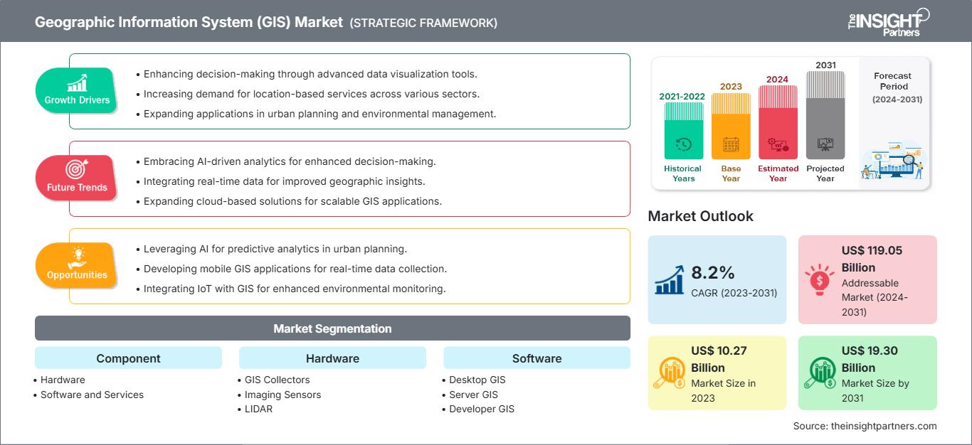
According to the cited market analysis, The geographic information system (GIS) market size is expected to reach US$ 19.30 billion by 2031 from US$ 10.27 billion in 2023. The market is estimated to record a CAGR of 8.2% from 2023 to 2031. The launch of AI, Gen AI, and augmented reality-based GIS solutions is likely to bring new trends to the market in the coming years.
Get Sample PDF of the report @ https://www.theinsightpartners.com/sample/TIPTE100000579
What Is Driving the Geographic Information System Market?
One of the major factors supporting GIS market growth is the increasing development of smart cities and digital infrastructure. Municipal authorities use GIS to manage roads, utilities, public transportation, land records, water systems, energy infrastructure, and emergency services. By integrating spatial information with operational data, governments and businesses can improve planning, resource allocation, monitoring, and infrastructure management.
Another important driver is the growing need for natural disaster forecasting and management. GIS technologies combine geographic information, satellite imagery, weather information, and spatial analytics to support the monitoring and prediction of storms, hurricanes, wildfires, floods, and other natural hazards. This allows authorities and emergency organizations to identify vulnerable areas, coordinate response activities, and plan mitigation measures.
The growing demand for real-time location-based services in transportation and logistics is also creating opportunities. GIS can support live vehicle tracking, traffic monitoring, route optimization, infrastructure planning, and fleet management. As logistics networks become more complex, organizations increasingly require accurate geographic information to improve delivery efficiency, reduce operational costs, and enhance customer service.
How Is GIS Transforming Agriculture?
Agriculture is becoming an important application area for GIS technology. Farmers and agricultural organizations can use GIS with GPS, remote sensing, satellite imagery, and field data to monitor crop conditions, analyze soil characteristics, identify field boundaries, manage irrigation, and optimize resource utilization.
Precision agriculture is further increasing the importance of geospatial technologies. GIS-based systems can help farmers understand variations within individual fields and make more informed decisions about water, fertilizers, crop selection, and other inputs. The integration of artificial intelligence with GIS is also creating opportunities for more advanced agricultural analytics and automated decision support.
Geographic Information System Market Trends
A major emerging trend is the integration of artificial intelligence (AI), generative AI, and augmented reality (AR) with GIS platforms. AI can help organizations analyze large volumes of spatial data, identify patterns, automate mapping processes, and generate insights more efficiently. Generative AI may further simplify interaction with geographic datasets by allowing users to obtain information through natural-language queries.
Another significant trend is the increasing adoption of cloud-based and mobile GIS solutions. Mobile GIS enables field workers, engineers, surveyors, utility operators, and agricultural professionals to collect and access geographic data from different locations. Cloud deployment can also improve data accessibility, collaboration, scalability, and integration across organizations.
The increasing use of LiDAR, GNSS, imaging sensors, remote sensing, and 3D mapping is another important development. These technologies provide highly detailed spatial information for applications such as infrastructure development, urban planning, surveying, environmental monitoring, and construction.
Geographic Information System Market Segmentation
The GIS market can be analyzed across component, function, and end-user categories. By component, the market includes hardware, software, and services, with software representing the largest component segment in 2023. Within hardware, offerings include GIS collectors, imaging sensors, LiDAR, total stations, and GNSS or GPS antennas. Software categories include desktop GIS, server GIS, developer GIS, mobile GIS, and remote sensing software.
By function, GIS applications include mapping, surveying, telematics and navigation, and location-based services. Mapping held the leading position in 2023, while telematics and navigation is projected to experience strong growth during the forecast period.
By end user, the Geographic Information System Market covers agriculture, oil and gas, construction, mining, transportation and logistics, energy and utilities, and other industries. Transportation and logistics represented the largest end-user segment in 2023, reflecting the importance of geographic intelligence in route planning, fleet management, infrastructure development, and location-based operations.
Regional Outlook for the GIS Market
North America held the largest share of the global GIS market in 2023, accounting for 34.7%. The region benefits from advanced digital infrastructure, smart city initiatives, technological innovation, and widespread adoption of GIS across government and commercial applications.
Asia Pacific is expected to be one of the fastest-growing regional markets, with a projected CAGR of 9.7% during the forecast period. Expanding urbanization, infrastructure development, digital transformation, agriculture modernization, and smart city programs are supporting demand across countries in the region. The United States market is also projected to grow at a CAGR of 7.7%.
Get the Premium Research Report @ https://www.theinsightpartners.com/buy/TIPTE100000579
Competitive Landscape
The GIS market includes established technology companies and specialized geospatial solution providers.
- Autodesk, Inc.
- Topcon Positioning Systems, Inc.
- Caliper Corporation
- SuperMap Software Co., Ltd.
- Hexagon AB
- Hi-Target
- Pitney Bowes Inc.
- Maxar Technologies
- AmigoCloud, Inc.
- Trimble Inc.
- Bentley Systems, Incorporated
- Cadcorp Limited
- Spatialworks Sdn Bhd.
- Environmental Systems Research Institute, Inc.
- Blue Marble Geographics
Future Outlook
The future of the GIS market is closely connected with the development of AI-powered analytics, real-time location intelligence, 3D visualization, cloud computing, remote sensing, and connected infrastructure. As organizations seek faster and more accurate insights from geographic data, GIS is moving beyond traditional mapping toward intelligent spatial decision-making.
About The Insight Partners
The Insight Partners is a global leader in market research, delivering comprehensive analysis and actionable insights across diverse industries. The company empowers decision-makers with data-driven intelligence to navigate evolving markets and accelerate growth.
Contact Us:
- Contact Person: Ankit Mathur
- E-mail: ankit.mathur@theinsightpartners.com
- Phone: +1-646-491-9876
Also Available in :
