Key Highlights
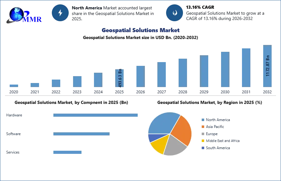
- The Geospatial Solutions Market was valued at USD 493.63 billion in 2025, showing that location intelligence has become a major enterprise and public-sector technology asset.
- The market is expected to reach nearly USD 1,172.87 billion by 2032, expanding opportunities for GIS software providers, satellite companies, cloud platforms, infrastructure developers and smart city operators.
- The market is projected to grow at a CAGR of 13.16% from 2026 to 2032, indicating rising demand for mapping, analytics, remote sensing and real-time geospatial data.
- GIS and geospatial analytics dominated the market in 2025 because of their wide use in mapping, planning, spatial analysis and operational decision-making.
- 3D scanning is gaining momentum in construction, infrastructure modeling, urban planning and high-precision visualization.
- Defense and intelligence led the end-user segment in 2025 because of strong demand for surveillance, mission planning and threat detection.
- North America dominated the market, while Asia Pacific is emerging as a rapidly growing region due to infrastructure development, urbanization and digital transformation.
Why This Matters Now
Location data is becoming a core operating layer for digital economies. Governments, enterprises, utilities, logistics providers, telecom operators and defense organizations are using geospatial intelligence to understand assets, people, infrastructure and risks in real time.
The Geospatial Solutions Market Size was valued at USD 493.63 billion in 2025. That value shows that mapping and spatial analytics have moved beyond specialist use cases and now influence transportation, smart cities, agriculture, security, infrastructure and enterprise operations. The market is expected to reach nearly USD 1,172.87 billion by 2032, creating a larger technology opportunity for software companies, satellite operators, cloud providers and analytics platforms.
The market is expected to grow at a CAGR of 13.16% from 2026 to 2032. This growth rate signals rising investment in digital infrastructure, real-time monitoring and data-driven planning. The strategic issue for technology leaders is no longer whether they need geospatial data. It is whether they can turn location data into faster decisions, automated workflows and secure digital services.
Market Overview
Geospatial solutions include tools and technologies used to collect, visualize and analyze location-based data. These systems combine mapping, satellite imagery, GPS, remote sensing, sensors, geographic information systems and analytics platforms.
The market supports applications across transportation, utilities, defense, infrastructure, natural resources, business operations and urban planning. Organizations use geospatial solutions to map assets, optimize routes, monitor land, assess risk, manage infrastructure and improve operational visibility.
The report identifies rising demand for location-based services as a major market driver. Ride-sharing, food delivery and logistics companies rely on real-time tracking and route optimization to improve customer experience and operational efficiency. This makes geospatial technology an essential part of platform-based business models.
Satellite technology is also improving the quality of geospatial data. Higher-resolution imagery and better data accuracy are supporting agriculture, environmental monitoring, urban planning and infrastructure management. More precise data gives enterprises and public agencies a stronger basis for planning and risk assessment.
The growth of IoT devices is expanding the market further. Connected sensors can generate location-based information from vehicles, buildings, roads, industrial sites and public infrastructure. Smart city programs use these data streams for traffic management, energy optimization and public safety.
Key Trends Driving Growth
Artificial intelligence is changing the role of geospatial analytics. AI-enabled systems can process large volumes of imagery, sensor data and mapping information faster than manual workflows. This improves the ability to identify patterns, detect changes and respond to operational events.
Machine learning is helping organizations automate spatial analysis. Companies can use algorithms to classify land use, detect infrastructure changes, monitor environmental conditions and support predictive maintenance. The business value lies in reducing manual analysis while improving response speed.
The integration of geospatial technology with IoT is creating new automation opportunities. Connected devices generate continuous location data that can be analyzed for traffic flow, asset movement, utility performance and public safety. This supports smart city operations and industrial monitoring.
5G technology is also supporting new geospatial applications. Faster connectivity can improve real-time asset tracking, augmented reality navigation and data transmission from connected devices. Telecom operators can use location intelligence to improve network planning, infrastructure deployment and customer service.
Autonomous vehicles are increasing demand for high-definition maps and real-time geospatial data. Autonomous driving systems require accurate location information to support navigation, safety and route planning. This creates opportunities for mapping companies, sensor providers and software platforms.
Cloud computing is changing how geospatial data is stored and processed. Cloud platforms can provide scalable computing capacity for satellite imagery, mapping databases and analytics workloads. This supports collaboration across organizations, but it also increases the need for secure data governance.
Cybersecurity and data privacy are becoming critical issues. The report highlights concerns around location data exposure, including the risk of revealing sensitive activity or infrastructure locations. Organizations need stronger privacy controls, secure access systems and clear data policies to maintain trust.
Interoperability remains a major challenge. Different geospatial platforms, sensors and data formats can make integration difficult. Enterprises need standardized data models and open interfaces to connect mapping systems with business software, cloud platforms and operational technology.
Segment Insights
- Dominant Segment: GIS and Geospatial Analytics — GIS and geospatial analytics dominated the market in 2025 due to their broad use in mapping, spatial data analysis and decision-making across industries.
- Fastest-Growing Opportunity: 3D Scanning — 3D scanning is gaining momentum because it supports high-precision visualization for urban planning, construction, infrastructure modeling and digital twins.
- Leading End-User Segment: Defense and Intelligence — Defense and intelligence led the market because organizations rely on real-time geospatial data for surveillance, mission planning and threat detection.
- Infrastructure Opportunity: Utilities and Infrastructure Development — Utilities and infrastructure organizations are adopting geospatial tools for asset tracking, planning, maintenance and network visibility.
- Enterprise Opportunity: Transportation and Natural Resources — Transportation companies use geospatial systems for logistics optimization, while natural resource organizations use them for land management and sustainable resource planning.
Regional Growth Story
North America dominated the Geospatial Solutions Market in 2025. The United States holds a significant share because of major geospatial technology providers, strong digital infrastructure and extensive adoption across transportation, agriculture and defense.
NASA’s Earth Observation System and investment in autonomous vehicle development are supporting market growth in the region. These initiatives strengthen demand for satellite data, mapping platforms, location analytics and real-time navigation systems.
Europe follows North America, supported by environmental, urban planning and infrastructure initiatives. The European Space Agency’s Copernicus program is helping expand access to Earth observation data. Germany and the United Kingdom are at the forefront of regional geospatial innovation through the use of LiDAR, satellite imagery, precision agriculture and smart city technologies.
Asia Pacific is emerging as a rapidly growing market. China and India are expanding the use of geospatial solutions in construction, utilities, transportation and urban development. Urbanization, infrastructure investment and digital transformation are creating demand for mapping, analytics and location-based services.
China’s BeiDou Navigation Satellite System is contributing to regional market development. India’s Smart Cities Mission is also increasing demand for geospatial data, traffic monitoring, urban planning and public infrastructure management. Japan and South Korea remain important technology markets because of advanced digital infrastructure, transportation systems and smart city investment.
The regional opportunity depends on satellite access, cloud infrastructure, digital regulations and the availability of skilled geospatial professionals. Countries that combine data access with strong technology ecosystems will be better positioned to build location intelligence platforms at scale.
Competitive Landscape
The market includes software providers, mapping companies, satellite operators, cloud platforms, engineering firms and analytics specialists. Key companies covered in the report include Esri, Pitney Bowes, Bentley Systems, Apple, Oracle, Microsoft, Amazon, IBM, HERE Technologies, Hexagon AB, TomTom International, SAP, Baidu, Trimble, Planet Labs PBC, BlackSky Technology and Autodesk.
Competition is moving toward integrated platforms. Companies that combine mapping, analytics, satellite imagery, cloud computing and enterprise software can offer customers a broader decision-making environment. This increases the value of data ecosystems over isolated mapping tools.
Cloud providers are becoming more important because geospatial workloads require large storage capacity and computing power. Enterprises need to process imagery, sensor data and real-time location feeds without building all infrastructure internally. This creates opportunities for cloud platforms that can provide scalable, secure and compliant geospatial services.
Satellite companies are also strengthening their market position by improving imagery resolution and delivery speed. High-quality Earth observation data can support defense, agriculture, environmental monitoring, logistics and infrastructure planning. The competitive advantage will depend on how quickly companies can turn raw imagery into actionable insights.
Software vendors are focusing on interoperability. Customers increasingly need geospatial data to connect with asset management, enterprise resource planning, transportation systems and smart city platforms. Companies that offer open APIs and strong integration capabilities can become central to digital infrastructure ecosystems.
Recent Developments
- Trimble adopted the ISO 15143-4 Worksite Topographical Data standard in March 2026 to improve interoperability across mixed construction fleets.
- BlackSky commissioned its third Gen-3 satellite in February 2026, expanding access to very-high-resolution imagery for commercial operations.
- Planet Labs launched AI-enabled Pelican-5 and Pelican-6 satellites in November 2025 with onboard edge computing capabilities using NVIDIA Jetson technology.
- Planet Labs established a satellite manufacturing facility in Berlin in September 2025 to expand Pelican satellite production capacity.
- Hexagon entered into an agreement to acquire Aero Photo Europe Investigation in June 2025 to strengthen aerial mapping and elevation model capabilities.
- TomTom was selected by smart in April 2025 to provide navigation and EV services for its global vehicle lineup.
Strategic Implications
For CIOs, geospatial systems are becoming enterprise data platforms. Location intelligence must connect with cloud infrastructure, IoT networks, business applications and cybersecurity controls. Organizations that treat mapping as a standalone tool may miss the broader value of spatial analytics.
For telecom operators, geospatial technology can improve network planning, asset management and 5G deployment. Real-time location data can support infrastructure maintenance, field workforce coordination and customer service. It can also enable new enterprise services around connected vehicles, smart logistics and city infrastructure.
For governments, geospatial platforms can support disaster response, urban planning, public safety and environmental management. However, privacy, data sovereignty and interoperability will determine whether these systems gain public trust and deliver long-term value.
For investors, the market offers exposure to AI analytics, satellite infrastructure, cloud computing, smart cities and digital twins. The strongest opportunities may emerge where companies combine proprietary data, scalable platforms and industry-specific applications.
Future Outlook
The Geospatial Solutions Market is moving toward AI-enabled, cloud-connected and real-time location intelligence platforms. Satellite imagery, IoT sensors, 5G connectivity and machine learning will increasingly turn geographic data into operational decisions across cities, enterprises and critical infrastructure.
Future digital leaders will use geospatial intelligence to automate decisions across physical and digital networks, while laggards will remain limited by fragmented data, slow analytics and disconnected infrastructure systems.
Analyst Perspective
“Geospatial solutions are becoming essential to digital infrastructure as organizations use mapping, analytics, IoT and AI to improve operational visibility and decision-making. Companies that can combine real-time location data with scalable cloud platforms and secure analytics will be well positioned to capture the next phase of market growth,” said Yash Ghosalkar, Analyst.
About Maximize Market Research
Maximize Market Research Pvt. Ltd. (MMR) is a global market research and consulting company that provides reliable, data-focused, and practical business insights. The firm serves a wide range of industries, including healthcare, pharmaceuticals, technology, automotive, electronics, chemicals, personal care, and consumer goods. Through market forecasts, competitive analysis, strategic consulting, and industry impact assessments, MMR helps organizations understand changing market conditions, identify growth opportunities, and make informed business decisions for long-term success.
2nd Floor, Navale IT Park Phase 3
Pune Banglore Highway, Narhe
Pune, Maharashtra 411041, India
+91 9607365656
sales@maximizemarketresearch.com
