Key Highlights
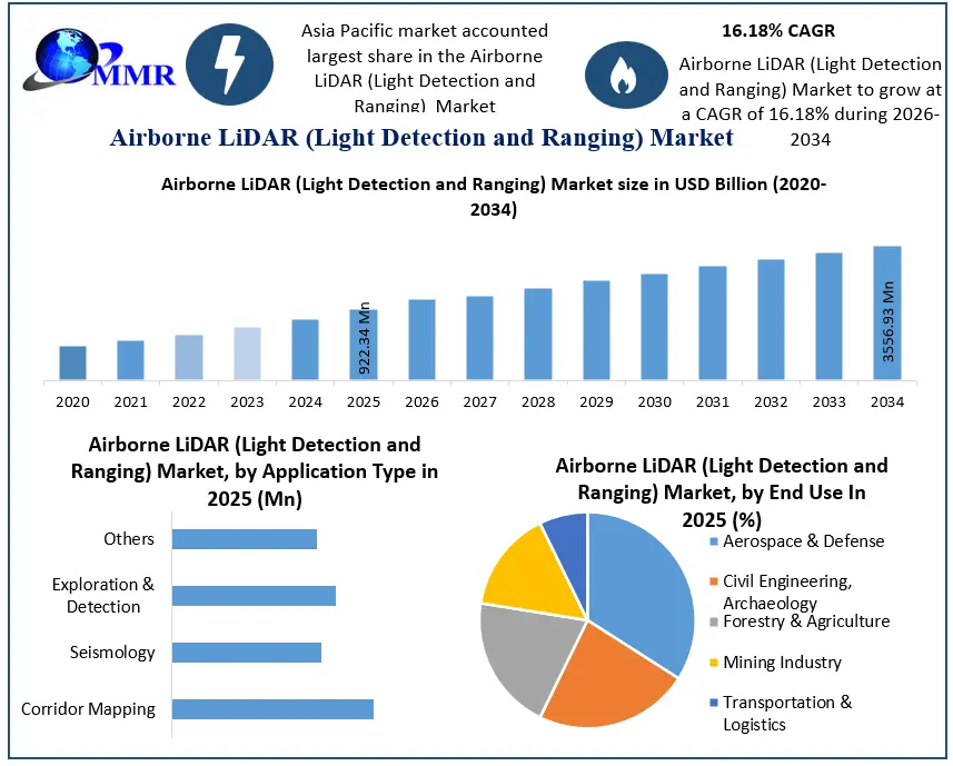
- Global market valued at USD 922.34 million in 2025.
- Forecast to reach USD 3.56 billion by 2034.
- Expected CAGR stands at 16.18% during 2026–2034.
- Asia Pacific remains the largest regional market, supported by infrastructure and surveying investments.
- Transportation and logistics emerges as the fastest-growing end-user segment.
- UAV deployment continues to expand commercial airborne LiDAR adoption.
- Defense modernization and digital mapping programs strengthen long-term demand.
- AI-enabled LiDAR data processing is improving survey productivity and operational efficiency.
Why This Matters Now
Governments and private operators are shifting from traditional surveying methods to high-resolution geospatial intelligence. Infrastructure expansion, railway modernization, renewable energy projects, mining exploration, and disaster management increasingly require precise elevation data delivered in significantly shorter project timelines. At the same time, UAV technology has lowered deployment costs, making airborne LiDAR accessible beyond defense and large engineering firms. Companies investing in AI-enabled processing platforms and longer-range sensors are positioned to capture the next wave of demand as mapping projects become larger and more data-intensive.
Market Overview
Airborne LiDAR Market combines laser ranging, GPS/GNSS positioning, inertial navigation systems, and imaging technologies to generate highly accurate three-dimensional terrain models from aircraft and unmanned aerial vehicles. The technology serves industries where centimeter-level elevation accuracy directly improves planning, construction, environmental monitoring, and operational safety.
Market demand is primarily driven by infrastructure development, defense modernization, mining exploration, forestry management, precision agriculture, and transportation corridor planning. Public investments in national mapping programs and smart infrastructure projects continue to expand procurement opportunities for airborne LiDAR equipment and surveying services.
Supply dynamics are also evolving. Manufacturers are integrating longer-range lasers, lighter payloads, AI-powered point cloud processing, and improved navigation systems to increase operational efficiency while reducing survey costs. These innovations enable larger geographic coverage with fewer flights, creating measurable productivity gains for service providers.
Macroeconomic factors including urbanization, climate resilience planning, renewable energy development, and digital transformation initiatives continue to support long-term investment across global geospatial technologies.
Key Trends Driving Growth
The industry is witnessing rapid innovation in UAV-compatible LiDAR platforms. Compact sensors with extended ranging capabilities allow operators to survey mountainous terrain, forests, transmission corridors, and coastal regions more efficiently while reducing operational costs.
Artificial intelligence is becoming an integral component of LiDAR workflows. Automated classification of vegetation, utilities, buildings, and terrain significantly shortens processing time and improves decision-making for infrastructure operators.
Government investment in digital infrastructure and national geospatial programs continues to accelerate adoption. Defense agencies are also expanding airborne LiDAR deployment for military mapping, border surveillance, and mission planning.
Sustainability initiatives are creating additional demand. Forest monitoring, watershed management, carbon assessment, and environmental conservation projects increasingly rely on airborne LiDAR to generate accurate ecosystem data supporting climate adaptation strategies.
International infrastructure development and cross-border engineering projects are further expanding demand for standardized aerial surveying solutions capable of delivering consistent datasets across multiple jurisdictions.
Explore detailed analysis, insights, and growth opportunities
Segment Insights
Dominant Segment: Aerospace & Defense
The aerospace and defense sector remains the largest end-user of airborne LiDAR technology. Military organizations require precise terrain intelligence for navigation, mission planning, surveillance, and strategic infrastructure development. High-resolution mapping reduces operational uncertainty while supporting advanced defense planning.
Business impact: Defense contracts provide manufacturers with long-term revenue visibility and encourage continuous investment in sensor innovation, software integration, and platform modernization.
Fastest-Growing Segment: Transportation & Logistics
Transportation and logistics is expected to record the fastest expansion throughout the forecast period. Highway authorities, railway operators, airports, and logistics infrastructure developers increasingly rely on aerial mapping for corridor planning, maintenance, and expansion.
Business impact: Faster surveying improves project execution, minimizes engineering risks, and reduces construction delays, strengthening demand for airborne LiDAR service providers.
Component Analysis
Lasers remain the core technology enabling accurate distance measurements across varying terrains.
GPS/GNSS receivers and inertial navigation systems enhance positional accuracy, allowing consistent data acquisition even in challenging environments.
High-resolution cameras complement LiDAR datasets by improving feature identification during post-processing.
Micro-electromechanical systems contribute to lighter airborne platforms, supporting broader UAV deployment.
Application Analysis
Corridor mapping continues to dominate commercial deployment due to increasing investments in transportation, utilities, and pipeline infrastructure.
Exploration and detection applications benefit mining companies searching for efficient geological assessment methods.
Seismology applications support disaster preparedness and geological monitoring, while other specialized applications continue expanding across environmental research and urban planning.
Regional Growth Story
Asia Pacific
Asia Pacific holds the largest market share and remains the fastest-expanding regional market. China, India, and Japan continue investing heavily in infrastructure, mining, agriculture, and government-led mapping programs. Rapid urban development and increasing UAV adoption strengthen regional demand.
Competitive advantage is gradually shifting toward regional service providers capable of delivering cost-effective surveying solutions for large-scale infrastructure projects.
North America
North America maintains a strong market position through advanced adoption across defense, industrial surveying, forestry management, and oceanographic mapping.
The United States benefits from a mature ecosystem of LiDAR manufacturers, software developers, and geospatial service providers. Canada continues expanding airborne LiDAR use in infrastructure modernization and environmental management.
Europe
European demand is supported by environmental monitoring, transportation modernization, archaeological research, and sustainable land management initiatives. Regulatory emphasis on environmental assessment continues encouraging deployment of advanced aerial mapping technologies.
Middle East, Africa and South America
Emerging economies are increasingly utilizing airborne LiDAR for mining, infrastructure planning, energy development, and natural resource management. Although market penetration remains lower than developed regions, investment activity continues to improve as governments prioritize digital infrastructure.
Competitive Landscape
The competitive environment is characterized by established geospatial technology companies competing through sensor performance, software capabilities, and integrated surveying solutions.
Teledyne Technologies and Leica Geosystems maintain strong positions through comprehensive geospatial portfolios serving government and commercial customers. RIEGL Laser Measurement Systems continues strengthening its market position through advanced airborne platforms optimized for specialized surveying applications.
Companies including Saab Group, FARO Technologies, Fugro, Merrick & Company, and Airborne Imaging leverage deep expertise across defense, engineering, and surveying services to expand customer reach. Meanwhile, emerging innovators such as CHC Navigation are increasing competitive pressure by introducing longer-range, UAV-optimized systems that improve operational efficiency.
Competition is increasingly shifting from hardware specifications toward integrated ecosystems combining sensors, AI-enabled software, cloud processing, and end-to-end geospatial services. Vendors capable of delivering complete workflow solutions are expected to strengthen their competitive positioning.
Recent Developments
- 17 June 2026 – CHC Navigation launched the AlphaAir 15 Pro, featuring a 3,200-meter ranging capability for large-scale aerial mapping.
- 1 June 2026 – RIEGL Laser Measurement Systems deployed AI-integrated airborne LiDAR mapping workflows for vegetation management projects in Eastern Canada.
- 14 April 2026 – CHC Navigation introduced the AlphaAir 6, optimized for complex high-relief terrain with a 2,100-meter ranging system.
- 16 February 2026 – RIEGL Laser Measurement Systems unveiled the lightweight RIEGL VUX-820-G topo-bathymetric airborne LiDAR platform alongside the VQ-1060 corridor mapping solution during Geo Week 2026.
Future Outlook
Organizations that combine long-range airborne LiDAR hardware with AI-driven geospatial analytics and scalable UAV operations will capture the strongest competitive advantage as infrastructure digitization and precision mapping become mission-critical worldwide.
Analyst Perspective — Rucha Deshpande
Airborne LiDAR is evolving from a specialized surveying tool into a core digital infrastructure technology. The convergence of UAV platforms, AI-powered data interpretation, and government investment in national mapping programs is expanding its commercial relevance far beyond traditional engineering applications. Companies that deliver integrated hardware, software, and analytics solutions rather than standalone sensors are likely to shape the next phase of market leadership.
About Maximize Market Research
Maximize Market Research Pvt. Ltd. (MMR) is a global market research and consulting company that provides reliable, data-focused, and practical business insights. The firm serves a wide range of industries, including healthcare, pharmaceuticals, technology, automotive, electronics, chemicals, personal care, and consumer goods. Through market forecasts, competitive analysis, strategic consulting, and industry impact assessments, MMR helps organizations understand changing market conditions, identify growth opportunities, and make informed business decisions for long-term success.
Contact Us :
2nd Floor, Navale IT Park Phase 3
Pune Banglore Highway, Narhe
Pune, Maharashtra 411041, India
+91 9607365656
sales@maximizemarketresearch.com
