Key Highlights
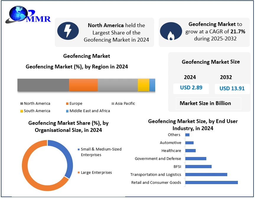
The global Geofencing Market size reached an institutional valuation of USD 2.89 billion in 2024 and is projected to expand to USD 13.91 billion by 2032.
The software sector operates on a highly accelerated growth matrix, advancing at a compounded annual growth rate (CAGR) of 21.7% from 2025 to 2032.
The retail and consumer goods segment held the dominant market footprint in 2024, driven by proximity marketing display advertisements.
The transportation and logistics application matrix represents a core high-velocity vertical, optimizing real-time container tracking and route security.
North America commanded the largest regional market share in 2024, supported by dense research spending and advanced smart city infrastructure setups.
Why This Matters Now
Fleet managers, Tier-1 telematics suppliers, and autonomous mobility strategists face immediate operational urgency as modern transit lines require total real-time visual tracking across regional boundary points. Legacy unnetworked cargo units expose global supply chains to high structural theft risks, forcing an immediate deployment of digital location-aware barriers to protect high-value assets during transit. Transport networks can no longer afford the routing delays caused by manual checkpoint logging when automated, instant geo-triggering arrays can execute depot check-ins with absolute precision. Component suppliers and software integration houses that delay embedding spatial tracking nodes into next-generation connected vehicle frameworks face quick commercial displacement by tier-1 brands locking down enterprise logistics contracts. With the marketplace scaling aggressively to hit a USD 13.91 billion endpoint by 2032, long-term sourcing victories belong to developers who eliminate physical boundary constraints via zero-hardware edge computing.
Market Overview
The global geofencing market covers the spatial software engineering, spatial data processing, and cloud deployment of location-based services (LBS) designed to establish virtual geographic boundaries. These intelligent architectures leverage GPS signals, RFID arrays, Wi-Fi points, and cellular towers to automatically trigger pre-programmed digital responses whenever a connected device crosses a specific virtual fence. The technology integrates directly into enterprise asset tracking, automated remote workforce check-ins, proximity marketing, and smart vehicle safety configurations. As high-speed 5G communications expand globally, these systems are migrating out of basic proximity alerting text setups into highly complex, AI-mapped geospatial tracking systems integrated into urban infrastructure.
Key Trends Driving Growth
Accelerating multi-sector demand for location-aware enterprise marketing acts as a massive engine for high-volume geofencing platform adoption. Businesses require highly granular user insight data to deliver targeted display advertisements directly to consumer smartphones as they move through local retail zones, maximizing click rates and driving brand retention. This behavior shift by large consumer brands ensures continuous, high-margin software license revenue for specialized location intelligence platforms worldwide.
Simultaneously, the widespread structural transition toward remote and hybrid operations acts as a core catalyst for workforce tracking integration. Organizations are utilizing geofencing software modules to facilitate accurate employee check-ins without physical keycards, cutting administrative overhead while optimizing overall project time control. Furthermore, the rapid integration of big data analytics into vehicle telematics forces transit managers to adopt virtual borders to monitor driver behavior patterns and secure high-value cargo across distant logistics networks.
Segment Insights
Retail and Consumer Goods [Dominant Segment]: This end-user industry classification captured the maximum share of the global marketplace in 2024. Retail chains prioritize spatial software arrays to run automated in-store navigation guides and deploy personalized real-time consumer discounts.
Transportation, Logistics, and Automotive [High-Velocity Verticals]: These combined transport tracking segments leverage virtual spatial barriers for automated route optimization, immediate depot gate check-ins, connected car software validation, and real-time transit field tracking.
Active and Hardware-Less Geofencing [Fastest-Growing Trend]: Driven by the institutional push to eliminate physical sensor footprints, hardware-free virtual boundary mapping represents the fastest-growing technology setup, lowering overall installation expenditure by using advanced software code instead of localized physical tags.
Regional Growth Story
North America commanded the dominant position in the global geofencing market landscape in 2024, housing the most established economic core utilizing advanced R&D structures. The region benefits from dense infrastructure investments, widespread high-speed cellular networks, and the concentrated headquarters presence of major spatial developers including Esri and Radar Labs. The deployment strategy focuses heavily on embedding geographic information platform software into regional smart city initiatives and public safety networks.
Conversely, the Asia-Pacific region displays rapid volume growth velocity, driven by expanding mobile connectivity and digital enterprise transformations across India and China. Emerging market zones are leveraging federal technology frameworks—including the Digital India program—to fast-track the deployment of beacon sensors and location-aware application infrastructure across local small and medium businesses.
Competitive Landscape
The competitive matrix of the global geofencing market is highly intense, defined by a group of prominent technology platforms possessing deep spatial mapping capabilities and advanced cloud hosting architectures. Pricing power belongs to software developers who can deliver highly accurate location tracking without draining user device battery capacity, a major operational hurdle across mobile platforms. Major industry participants protect their market share by executing continuous AI feature expansions and offering scalable software development kits (SDKs) to secure deep integrations into high-volume consumer mobile applications. Niche spatial analytics startups and independent software vendors are adjusting by forming tight data integrations with cloud platforms or specializing in hyper-accurate vehicle tracking to capture specific enterprise logistics needs without directly competing against global software giants.
Recent Developments
Global location intelligence leader Esri expanded its enterprise footprint by deploying its advanced ArcGIS tool into smart city configurations to manage real-time public disaster response logistics.
Specialty spatial mapping vendor Radar Labs, Inc. achieved a 20% year-over-year revenue surge, fueled by massive user adoption across on-demand delivery apps and location-based marketing channels.
Automated location developer Bluedot scaled its platform capabilities by engineering its patented “Geoline” technology, securing five-meter tracking accuracy without using localized physical hardware structures.
Top-tier cloud infrastructure providers—including Google LLC, Apple Inc., and Microsoft Corporation—upgraded their core location APIs to support massive geo-triggering volumes from automated commercial vehicle systems.
Strategic Implications
For logistics software engineers and Tier-1 telematics developers, the rapid marketplace transition toward high-speed automation requires an immediate focus on hardware-less spatial mapping frameworks. Eliminating local sensor deployment costs allows software providers to offer massive scalability advantages to fleet management operators seeking to monitor thousands of container routes simultaneously.
Furthermore, to counteract the high device costs that restrict traditional hardware tracking setups, software providers must optimize their applications to function perfectly on standard, consumer-grade mobile devices. Developers must also align their long-term technical platforms with the massive smart device rollouts expanding across the Asia-Pacific region, ensuring that localized software code interfaces cleanly with the high-speed 5G networks spreading through China and India.
Future Outlook
The ultimate line of separation in the global enterprise tracking space will isolate advanced spatial software pioneers who master hardware-free, AI-mapped geofencing systems from legacy hardware suppliers stuck installing expensive, signal-restricted physical tracking tags.
Analyst Perspective
“The global geofencing market is navigating a profound evolution where traditional physical hardware boundaries are giving way to intelligent, cloud-managed software perimeters,” states Dharati Raut, Research Analyst at Maximize Market Research. “As connected vehicle fleets and proximity marketing campaigns scale up globally, the engineering ability to deliver sub-five-meter spatial accuracy without localized physical hardware will determine which platform architectures command future enterprise contracts.”
About Maximize Market Research
Maximize Market Research Pvt. Ltd. (MMR) is a global market research and consulting company that provides reliable, data-focused, and practical business insights. The firm serves a wide range of industries, including healthcare, pharmaceuticals, technology, automotive, electronics, chemicals, personal care, and consumer goods. Through market forecasts, competitive analysis, strategic consulting, and industry impact assessments, MMR helps organizations understand changing market conditions, identify growth opportunities, and make informed business decisions for long-term success.
2nd Floor, Navale IT Park Phase 3
Pune Banglore Highway, Narhe
Pune, Maharashtra 411041, India
+91 9607365656
sales@maximizemarketresearch.com
