Market Overview
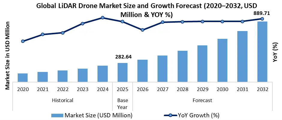
The Global LiDAR Drone Market is gaining momentum as organizations seek faster, safer, and more accurate methods of collecting spatial information. The technology combines drone mobility with LiDAR sensing capabilities to generate detailed three-dimensional representations of terrain, structures, and assets.
What changed is the role of aerial data. Historically, surveying required extensive fieldwork, significant labor resources, and lengthy project timelines. LiDAR-enabled drones have transformed that process by enabling rapid data collection across large and difficult-to-access areas.
This shift has strategic implications for multiple industries. Construction companies can accelerate project planning. Utility operators can improve asset monitoring. Mining companies can enhance operational visibility. Environmental agencies can obtain more accurate terrain and vegetation intelligence.
For semiconductor suppliers, every LiDAR platform requires advanced sensors, processors, communication modules, memory components, and power-management systems. Market expansion therefore contributes to demand across multiple electronic component categories.
Key Trends Driving Growth
The strongest growth driver is the increasing demand for geospatial intelligence. Organizations need precise digital representations of physical environments to improve decision-making, reduce operational risk, and support infrastructure planning.
Artificial intelligence is amplifying the value of LiDAR datasets. Drone platforms increasingly combine LiDAR sensors with AI-powered analytics that automate object recognition, terrain classification, anomaly detection, and infrastructure assessment. This reduces analysis time while improving operational efficiency.
Smart infrastructure initiatives are also creating substantial opportunities. Governments and municipalities increasingly require detailed mapping data for transportation networks, utility systems, environmental management programs, and urban development projects.
The rise of autonomous operations is another important trend. Advanced navigation systems, onboard processing capabilities, and intelligent flight-management software are reducing operational complexity while expanding commercial use cases.
Industrial inspection continues to evolve as a high-value application. Utilities, telecommunications providers, energy companies, and transportation operators increasingly deploy LiDAR drones to inspect critical assets. These systems improve safety while minimizing manual inspection requirements.
The broader technology ecosystem is also benefiting. Growth in LiDAR deployment supports demand for advanced semiconductors, edge-computing platforms, communications technologies, cloud infrastructure, and AI-processing solutions.
Request a Free Sample Copy or View Report Summary: https://www.maximizemarketresearch.com/request-sample/66123/
Segment Insights
Dominant Segment: Corridor Mapping
Corridor mapping maintains a leading position due to extensive use in transportation infrastructure, utility networks, pipelines, rail systems, and power transmission projects.
Dominant Segment: Infrastructure Applications
Infrastructure inspection and monitoring remain major deployment areas because governments and enterprises increasingly prioritize asset visibility and maintenance efficiency.
High-Growth Opportunity Segment: Environmental and Forestry Monitoring
Expanding sustainability initiatives and environmental management requirements are creating opportunities for advanced LiDAR data collection and analysis.
Emerging Opportunity: Autonomous Surveying
Increasing automation capabilities are supporting broader adoption of drone-based surveying systems across commercial industries.
Technology Opportunity: AI-Integrated LiDAR Platforms
Integration of artificial intelligence with LiDAR-generated datasets is enabling faster insights and higher-value decision support.
Regional Growth Story
North America continues to represent a significant market for LiDAR drone technologies. The region benefits from advanced technology adoption, strong infrastructure investment, established drone ecosystems, and increasing demand for geospatial intelligence across both public and private sectors.
The United States remains a key innovation hub. Demand for infrastructure modernization, utility inspection, environmental monitoring, and commercial surveying continues to support technology deployment. The presence of leading drone manufacturers, software developers, and sensor providers further strengthens regional competitiveness.
Asia-Pacific is becoming increasingly important as governments invest in infrastructure development, smart-city programs, and digital transformation initiatives. Countries including China, Japan, South Korea, and India continue expanding their use of advanced mapping technologies for transportation, construction, and urban planning projects.
Europe is also advancing adoption through sustainability initiatives, infrastructure modernization efforts, and environmental monitoring programs. The region’s focus on digitalization and smart infrastructure creates favorable conditions for LiDAR drone deployment.
The regional story is not solely about drone demand. It also reflects broader investments in semiconductors, communication technologies, AI platforms, and intelligent infrastructure systems that support the deployment of advanced sensing solutions.
Competitive Landscape
Competition increasingly centers on ecosystem capabilities rather than hardware alone. Market participants are pursuing strategies that combine sensing technology, software analytics, autonomous operations, cloud connectivity, and data-management platforms.
The most significant signal from the competitive landscape is the growing convergence of hardware and intelligence. Companies that can combine high-performance LiDAR sensors with advanced AI analytics gain stronger positioning than those competing solely on drone specifications.
Technology leadership increasingly depends on data-processing capabilities. The value of a LiDAR drone is no longer determined exclusively by data collection performance. Customers increasingly evaluate how effectively platforms transform raw information into actionable intelligence.
The market also highlights the importance of semiconductor innovation. Sensor accuracy, power efficiency, onboard processing performance, memory capacity, and communication capabilities directly influence system competitiveness.
For electronics manufacturers, the market creates opportunities to participate in rapidly expanding demand for sensing, computing, and connectivity technologies. For investors, it represents exposure to multiple growth themes including AI, automation, infrastructure modernization, and digital transformation.
Recent Developments
Increasing adoption of AI-powered LiDAR analytics.
Expansion of drone-based infrastructure inspection programs.
Growing deployment of autonomous surveying technologies.
Rising demand for environmental monitoring applications.
Broader use of geospatial intelligence platforms.
Improvements in sensor accuracy and data-processing capabilities.
Greater integration of cloud-based analytics with aerial mapping systems.
Strategic Implications
For semiconductor manufacturers, LiDAR drones represent a growing source of demand for sensors, processors, communication modules, memory devices, and power-management components. Every increase in deployment expands opportunities throughout the electronics value chain.
For OEMs and drone manufacturers, competitive differentiation increasingly depends on software intelligence, autonomy, and analytics capabilities rather than airframe design alone.
For governments and infrastructure operators, LiDAR drones offer a pathway toward more efficient asset management, improved planning accuracy, and enhanced operational resilience.
For investors, the market provides exposure to several long-term technology themes simultaneously: AI adoption, edge computing, autonomous systems, digital infrastructure, and advanced sensing technologies.
The strategic opportunity extends beyond mapping. LiDAR drones are becoming foundational tools for digital twins, predictive maintenance, smart-city management, and next-generation infrastructure intelligence.
Future Outlook
The industry is moving toward a future where autonomous LiDAR platforms continuously collect, process, and analyze spatial data in real time. Companies that combine advanced sensors, AI-driven analytics, edge computing, and scalable data ecosystems will define the next generation of geospatial intelligence, while competitors focused solely on hardware risk being displaced by software-led technology leaders.
Analyst Perspective
“LiDAR drone technology is evolving from a specialized surveying tool into a critical platform for geospatial intelligence. The convergence of advanced sensing, AI analytics, and autonomous operations is creating new opportunities across infrastructure, environmental monitoring, and industrial applications.” — Rucha Deshpande
About Maximize Market Research
Maximize Market Research Pvt. Ltd. (MMR) is a global market research and consulting company that provides reliable, data-focused, and practical business insights. The firm serves a wide range of industries, including healthcare, pharmaceuticals, technology, automotive, electronics, chemicals, personal care, and consumer goods. Through market forecasts, competitive analysis, strategic consulting, and industry impact assessments, MMR helps organizations understand changing market conditions, identify growth opportunities, and make informed business decisions for long-term success.
2nd Floor, Navale IT Park Phase 3
Pune Banglore Highway, Narhe
Pune, Maharashtra 411041, India
+91 9607365656
sales@maximizemarketresearch.com
